Sunday, September 29, 2013

Day 7 August 22th Upper Mongolia, Seattle

Some random guy early in the morning on the way to the ferry
The Road
We left Jenny’s at 5:00AM made the quick ride down on the Elliot Bay Trail to catch the 6AM ferry to Bainbridge. It was pretty unremarkable road riding for most of the day. We took whatever back roads we could find up to Port Gamble, Across the Hood Canal Bridge and 101 onward toward Sequim. We ran into a biking couple from Austria biking around the state. The guy had a great horn. Just before Sequim we got on the Olympic Discovery Trail and took it into town.
Sunrise over Elliott Bay

Coming into Port Gamble
Sequim was our third and final stop at an Alzheimer’s facility. We were lucky that both Trisha Averill and Keri Pollock of the Alzheimer’s Association were at Discovery Memory Care. Once again we had a great stop visiting residents and talking about our trip. They gave us a huge bag of food and we were off for Port Angeles on the trail.

Getting on the Olympic discovery Trail


This trail is mostly railroad grade but they have lost a lot of the right of way and bridges. So the trail is on and off public road, big drops into rivers and climbs out, and strange 90 degree turns to steep climbs. This was not what we expected but the last few miles were right down along the Strait of Juan De Fuca and it was a beautiful ride into Port Angeles. Once there we went shopping for food and talking to a nice couple from France who had been biking across the continent for the last 4 months. I marked on their map where we lived, gave them my email, and invited them to stay with us. We rode out of town to a campground, had a large meal and relished our last night on the road.

Strait of Juan de Fuca
Stats for the day
92 miles At Goal
4,400ft ascent/4100ft descent
15hr 11min total time
More pics HERE

Thursday, September 26, 2013

Day 6 August 21th Snoqualmie Pass

WackieDoodle Land
Riding down the Old Snoqualmie Road
We got up early, pushed up to the pass and down the old Denny Creek Road. We girded ourselves to the ride on I-90 down to North Bend. Lights, Helmets, all our clothes and reflective triangles on, I led down and hammered it out. Once at North Bend, we got on the Snoqualmie Valley Trail and started following Robin’s directions to the Preston Fall City Trail. I told Robin that I wanted a clean route with no multi-hour navigation extravaganzas. But that is just what he gave us – an undecipherable labyrinth on a very bad map. I traveled 5 days without a compass and today I had to break it out. Trying the get through the development on Snoqualmie ridge is a real problem. Anyone you ask is helpful but can only do it in their car with a gps. What should have taken 15 minutes took us two hours but our reward for getting through was meeting up with Jerry Gamez in Preston and having him follow us into Issaquah.
Issaquah was our second Alzheimer’s stop At Aegis Living of Issaquah where we had a great lunch with Melissa Mather and her crew. During lunch Jerry offered to look at our bikes and this is when Mathew dropped a bombshell: If he stopped pedaling, his read wheel was making a horrible noise. It had been behaving like this since Ellensburg and he had hadn’t coasted at all during the last day and a half. We called a good friend Roger Micheal who lives up in Redmond and he agreed to meet us further up the trail with a replacement wheel. Riding on at this point the railroad grade was mostly paved and we were making good time up and around Lake Washington.
What a change. I think we saw more people in the first ½ hour on the Burke Gilman trail than we had seen in the previous 6 days combined. As we rode, we were passed left right and center. They rode fast, didn’t talk much and grimaced a lot in their passive/aggressive way. Not a lot of happy people here. Like the Police said, packed like lemmings on top of shiny metal contraptions. This is the human race in the city. In a case of government inspired social correction of it residents, there were brightly colored signs all along the trail that read; “Be Super Safe”, “Stay Right Except to Pass”, “Use Your Light at Night”, “Use Your Bell or Voice When Passing”. Thereby replacing human interaction with government inspired mandates on Signs.

Since nobody seemed to be minding these signs, in a fit urban inspired madness, I began quoting these sayings to those who were not obeying the signs. I received a lot of strange looks and thought that I might get punched. In another fit of madness, I stopped where the trail crossed the UW entrance. I had a stop sign but also had a crosswalk. There were tons of cars and with this bit of inconsistent right of way; I followed the stop sign in front of the crosswalk waiting for traffic to clear. With me following the stop sign, cars were not sure if they we supposed to stop for the crosswalk and cyclists began stopping for the stop sign. Chaos ensued.
One of the many signs to help people get along

Upper mongolia in the distance
We soon saw upper Mongolia in the distance and my sister’s house grew near. While this stop was short of our goal camping spot just past Bainbridge Island, a ferry ride and 30 more miles of road where not in the cards. She was nice enough to offer her fold out couch, salmon dinner, a shower, and our fresh clothes bag were just what we needed. We cleaned out our trailers and almost fell asleep at dinner.
Our old tire collection
Stats for the day
90 miles 30 miles short of goal
1,800ft ascent/4100ft descent
11hr 34min total time

Tuesday, September 24, 2013

Day 5 August 20th Ellensburg

Rejuvenation
The prior day we were scheduled to make our first stop at Hearthstone Cottage, an Alzheimer’s facility at noon in Ellensburg. That didn’t happen. I suggested that we sleep in to 6:30 and visit them for breakfast. I got up at 6AM and was busy putting my bike back together. While I called and explained the situation to Recycle Cycle of Ellensburg and my daughter tried to explain they just didn’t get it and they didn’t bother calling. I said; repair, rebuild or recreate my wheel. Instead of a rim that was presta and fit my tires, I ended up with a shraeder rim that fit the bad Wal-Mart tires. That meant that I would not be able to use my maxxis semi-slick on the new rim with all the road riding that would be coming up in the end. This was a complete disappointment and I would really like to talk with the guy who did this to understand why? But my Turner was back under me and it felt great.
We spent an hour at the facility with Joan Allyn meeting the residents and explaining what we were doing, taking pictures and having a great breakfast. We finally got out at 9AM and rode west out of town. My daughter Sarah joined us for a few miles of this ride and as we parted with Mathew yelling for Sarah to tell Jenny to look to the East on the morning of the fifth day, I hoped it would take us 5 day to get to Seattle.
I knew that once we got to Ellensburg the trail would only get better and I was not disappointed. Mathew was focused on the pass but I knew that it would only get easier than the prior days. Our goal for the day was to get past the pass and find a camping spot on the western side of the Cascade Crest. The upper Yakima River canyon is beautiful and is worthy for future exploration and a paddle trip. We had lunch in Cle Elum and were quickly back on the trail.
We met our first bike travelers and horseman at this point of the trp. We also learned from them that there was a freak lightning strike ahead the knocked out the fiber optic lines west of the pass. The trail was closed and we would be riding down I-90 from the pass to North Bend. Once again we had the wind knocked out of us. the whole trip we were looking forward to the fun ride down that part of the trail… the good news was that we would cover shorter distance, move much faster and make up lost time. We would plan on camping as close to the pass as possible and head down I-90 as close to sunrise as we could before traffic got bad. We were not looking forward to it.
Along this part of the trail it gradually climbs but given the nice trail condition the climb is not noticeable. We were back in the trees after three days and the change was welcomed. This section of the trail is beautiful including the very expensive bridges they built. I have no idea why the state spent millions of dollars on bike bridges but they were nice.

Along this part of the trail it parallels the active BNSF line. As a train passed, it scared an animal up and out of the woods between the lines. At first I thought that this was a strange place for a pussy cat and thought there must be a house nearby. Looking closer, I realized the cat was as big as my wheels and motioned Mathew to have a look. Before I could get out my camera it looked back and was gone. What was remarkable to me was that the cat was a dark brown and very scrawny. I wish I had gotten a picture. We ended up camping just east of the pass in a “backcountry” campsite. If these nice campsites were considered backcountry, I knew we were getting close to Seattle.
Stats for the day
57 miles 15 miles short of goal
1,200ft ascent/200ft descent
10hr 57min total time
More pics HERE

Friday, September 20, 2013

Day 4 August 19th Along Crab Creek

The Crucible
Coming into Smyrna and Goat Head Purgatory
Betsy hurt my back. The night was hot but we didn’t need the rain fly. We saw the space station again. There were no trains rolling by so we slept well. I was up at 4:30 to prep the bikes and make breakfast. It was going to be a long day. 100 yards out of camp I flatted. I replaced the tire with a non-slime tired and moved on. We were on farm road until the active line turned north to Royal Slope then we rejoined the abandon line heading west.


This was very beautiful farmland. Just west of Smyrna Mathew called out a flat. When we stopped he said you better have a look at your tires. Every tire was covered with goat’s heads. 26inchwheels had warned about this but I had forgotten. We were in a world of hurt. This is why we went with slime tubes but our bike slime tubes were worthless. The trailer tubes we made ourselves and they had lots of slime. Mathew was completely dejected. How do you repair dozens of holes with two tubes and limited patches? So one wheel at a time we pulled out the thorns and spun the wheels. Mathew’s wheels didn’t hold. My front wheel resealed and held and my back didn’t. We carefully pulled all the thorns out of Mathew tires with tweezers and replaced the tubes. We pulled the thorns out of my rear and started patching. We patched and rode and it would go flat again. We did this a few times and finally when it looked at its worst, I cut open one of our empty water jugs and filled it with water from my bladder to find all the holes. We patched the remaining 10 or so holes we found with patch pieces that we cut from our dwindling patches. We also repaired one of our holy spares. I kept the water pan and poured the dirty water into my empty bottle in case we needed it again.
Cut near Crab Creek


For those who will do this trip in the future, there is a white gate just west of Smyrna. Do not ride any trail east of this gate and you should miss the goat head zone.


Now we were on our last legs. Our bike tires have been repaired and are holding air. The trailer tires are still full of thorns. I decided to leave the thorns in the trailers and hoped they resealed as they leaked. If there was another patch of goat heads ahead, we were all done. We had one patched spare and a few patch pieces. All we could do was move on. I said a prayer to God and asked Joseph to pray with me as a father would do for his son. As I rolled over my bike, a pack of long forgotten old patches fell out of my saddle bag and I knew that we would be ok.
Tressel At Beverly
We pushed on having spent 2 hours on flats and still not at the Columbia River. When we arrived at the little town of Beverly on the Eastern shore of the Columbia it was noon and already very hot. We asked some workers for water and they let us use their hose and gave us two of the best apples I have ever eaten. We rested, had lunch and got ready for our climb up through the firing range.


The railroad trestle over the Columbia was locked and since Mathew did not get the combination, we would have had to ride about 20 miles around and over I-90 at Vantage. This was not an option so we climbed yet another and the hardest fence, walked our bikes across the mighty Columbia and set out on the long climb to Ellensburg. Since it is a railroad grade it is not steep. It climbs about 100ft per mile. However, it is at least 100 degrees, the wind is strong against, and the tread while not bad was still sand. This place is beautiful in its desolation. This would be a long day alone with our thoughts in the blistering heat.
Yakima firing Range notice the cuts in the distance

We slowly rode up in the heat stopping in patches of shade to eat, drink and rest. We constantly refigured the distance, climb, and time remaining until the top. We were excited to get to the top and ride down into Ellensburg fully expecting the evening Kittitas wind to be against us but still riding down to my daughter Sarah’s place with a shower, pizza, and my rebuilt bike. By now my back was hurting so much that I asked Mathew to take a pull in it. I was so glad to get on my old bike that fit well. Mathew’s first comments were, “How have you been riding this bike?” He took it to the top of the hill and let my back rest a while.
Tunnel at the top


We were excited to reach the top but our excitement was quickly tempered. Riding down to I-90 in a strong head wind, on tread that can only be described as cat litter, was harder than riding up. Our spirits waned greatly. It was getting late and a full night’s rest was slipping away. I was getting fearful that we might not make it to Ellensburg that night. There is a reroute around the trestle over I-90 and when we rejoined the trail 9 miles east of Ellensburg; I made an executive decision to ride the parallel road into town. Mathew didn’t like this idea but as it was, we arrived in Ellensburg after 9PM. Sarah had pizza waiting for us and the cleansing shower buoyed our spirits and helped us to sleep well that night.

Kititas Valley into the sunset


Stats for the day
63 miles 30miles short of goal
2,400ft ascent/1600ft descent
15hr 9min total time (longest day)
more pics can be found here

Thursday, September 12, 2013

Day 3 August 18th Lind


Lind Town Park


Disaster Strikes
After a horrible night sleep next to the active rail line and crossing signal we were happy to get on the road. The trail here is actively used and in great shape. We had about 25 miles to Warden and made great time. It was looking like our problems were behind us. We left town only to ride a mile and then get rerouted und
er an abandon bridge. It would have been better to just leave town on the highway for a mile to join the trail and avoid the bushwhack. The trail was fast and flat as we transitioned from dry land wheat farming to irrigated crops of the Columbia irrigation district. We started playing how far is it. On a long flat trail structures in the distance can appear deceptively close and we were busy passing many gates along this section.


Great riding here

Abandon bridge West of Lind


Abandon silo along the rail bed

Once in Warden we stopped for food and breakfast. As we rode in town on the pavement I heard a syncroness sound coming from my back wheel and decided to check on it on our way out. A nice lady thanked Mathew for what he was doing and told him that her mother had Alzheimer’s and was in a home in Moses Lake. We had a great breakfast and were off. The sound was ominous. If you have spent time around bikes you can tell sounds and feels that are serious and this was one of them. I quickly determined that it was not the brakes, cranks, or drivetrain but seemed to come from one part of the wheel and I suspended a broken or otherwise problematic spoke. We needed to get to Othello where there might be a bike store.


Active line between Warden and Othello


Lots of corn once in the Columbia Basin Irragation District


The rail line from Warden to Othello is still active so we used the route that 26inchslicks used that uses irrigation canal roads and other roads using the gazetteer. As we rolled into Othello on pavement the sound was now noticeably worse and had to be fixed before we set off into the wilderness between Othello and Ellensburg. We stopped to ask if there was a bike store and were pointed in the direction of Wal-Mart. I began to take apart my tire and what was an invisible hairline crack in my rim now presented itself as a crack almost the entire circumference of the wheel. We were out of commission as the bike was now unridable. The ruggedness of the trail had destroyed my old wheel with no fix in site.


Mathew looked dejected but my racing experience had prepared me for this eventuality and I was about to implement the RVG Betsy option but I needed help. First we went to Wal-Mart and after helping a young kid and his mom pick out a bike; I purchased the largest kid bike they had for $95. When the cashier offered replacement insurance I seriously considered it. We tuned it up on the spot, transferred any parts I could (tires, pedals, bottle cage) and went looking for help. Our first stop was the Othello Fire Department and after explaining our predicament they graciously agreed to help. First, they filled our bladders with ice water and agreed to hold my bike. Next, my father in-law Bob had offered us any help and I was about to ask for a big favor to which he agreed. He arrived from Moses Lake to take my broken bike to Ellensburg to have it fixed. Without his help we probably could not have finished the project.

 
Betsy is hooked up and the Turner is read to go to Ellensburg for repairs

And we were off except I was riding Betsy which was super heavy, too small, and didn’t quite work right. It turned out that the rail line has been refurbished all the way to Royal Slope so we were once again on farm road paralleling the trail. Given the day’s problems, we were well short of our goal of the Columbia River and we stopped to camp on some remote public land halfway between Othello and the Columbia.

 
Riding into the sunset along Crab Creek

Stats for the day
63 miles 10-20miles short of goal
1,000ft ascent/1600ft descent
13hr 11min total time
More Pictures can be found here

Sunday, September 08, 2013

Day 2 August 17th Middle of Rock Lake

Hot and Slow


Day 2 started at 6AM. The trail bed was fast, we were still going down slightly, and we had passed most of the rock debris. By mid-morning we had reached the town of Revere. We really only know the names of these long forgotten towns because they are still listed in the gazetteer. However, they are now mostly only grain silos next to the old railroad bed. Some of the grain silos are still in use but with trucks and some are abandoned. Revere had an active silo. We stopped to fill our water as all active silos have water. We talked to the guy working. It is harvest season as we knew from all the combines and trucks we had seen in the fields. The guy showed us how they unloaded and tested the grain for moisture content. Anything over 17% is rejected. He showed us his rattlesnake rattle collection which was about 30 and a skin. He said he had already collected two this year near the silo. And he talked about watching trains pass on the trail we now rode when he was a child.

When we left Revere the day became hard. The temperature was quickly rising, the grade was climbing, the rail bed was deteriorating, the wind was now steady in our face and against our trailers, and there would be very little shade for the next few days. I suspected the rail grade would become worse as it passed through a nature area and would be receiving little use. These conditions lasted until Marengo. This was one of the toughest parts of the trip. I was suffering but Mathew was doing fairly good. We passed through and area where we had done an orienteering event called the Rock Creek Ramble. I had seen this section before in April and knew it would be tough in August. During this section, I had a flat and a replacement slime tube stem broke when filling. That means our two replacement slime tubes were now used and from inspection of the tubes it was pretty clear that the slime in these old tubes would not be adequate in the coming days.
We rolled into Marengo around 2PM in pretty bad shape. There is now only one farm house and we headed toward it. I asked the very nice lady if we could have some water from her hose and a piece of her shady grass for a while. I never got her name but once again she was one of those kind persons who are always willing to help. After we ate, drank, and hosed ourselves down, cool clarity came back to us. She joined us on the lawn.

She was 84 years old and spent most of her life there. At this location the active Union Pacific crosses the Milwaukee and back in the day this was an active hub. There were many families and railroad workers. There was a depot and she traveled by train. Now it is just her and her son and I think a whole section of wheat fields. She quickly cut to the next issue facing us. “How are you going to cross Cow Creek” she asked. I hedged. I had heard that the bridge was out but after looking at detailed topo maps, Google earth and some early scouting, I thought we could make the 5 mile crossing easy with some bike whacking. The alternative was a very hilly 18 mile ride around on road that I really didn’t want to do. So I answered what would you suggest? To which she replied, “I wouldn’t try going that way unless you want to get shot”. She went on to explain that the adjacent land owner was a piece of work that we should avoid at all costs. So we took it to heart and girded ourselves for a long road ride.

In the end we made it to Ralston on the other end at just past 6PM and I gave Mathew three choices. First, camp in Ralston at the Park, second just get on the paved road to Lind which was about 15 miles and paralleled the trail, or third, try the trail but if it was bad surface move back to the road. Since my goal was to be able to get up early the next day and ride, riding the trail late into the night was not a feasible option. He chose option three and after a quarter of a mile, we were on the road which we knocked out in about 2 hours. Arriving in Lind at 8:30, we grabbed a burger in a tavern and set up out tent in the park next to the active UP line. This mistake came back to haunt us every 30 minutes throughout the night.

Stats for the day
66.5 miles At goal for second night
1,100ft ascent/1500ft descent
13hr 57min total time

Thursday, September 05, 2013

Day 1 August 16th Idaho Border Approximately 5 miles NE of Tekoa (TEE-KO), WA

Rancher Saves the DayWe got a late start at 7:08 after packing our gear and getting everything sorted out at the trailhead. The boys had made Mathew a sign for his trailer that he attached. My wife dropped us, took some pictures and drove off. We began our trip at about 2,800ft in the heart of Palouse country with golden waves of grain surrounding us and really nice road surface in front of us. What I would learn throughout the trip is that if farmers and other users used the trail it is generally in great shape. When not in use, it is degraded or unimproved.


Getting Ready
We made good time and shortly after telling Mathew that we would not see anybody for days, we ran into a nice woman out walking on the trial. After about 5 miles we came to the town of Tekoa. There is an old railroad trestle but they have blocked it off and we rode around down and under and then based on the gazetteer, rode out of town on roads to rejoin the trail.

Here the trail began to degrade, first the ballast became worse and plants began growing in the trail. Here I also learned that Mathew did not get the gate combination when he got his permit. One combination would be good for many gates and we learned that this would mean many bike/trailer passes over many gates to come.
Palouse Moose

Cheryl reappeared to cheer us on at a road crossing and shortly thereafter we saw the Palouse Moose. About 5-10 miles out of Tekoa the trail began to significantly degrade. The trail would go through large cuts and those cuts would retain water and also plant growth. For about 2 miles we bike wacked through 5-6ft deep grass and brush. After about 2 hours we got out the gazetteer to find an alternate route, climbed out of the cut and got on the parallel road. This lasted about ¼ mile and we saw that the trail was good again.

Riding to Rosalia was nice. The grade had been going down slightly from the start, the ballast wasn’t too bad but there were a lot of small removed bridges that we needed to ride down and around. Coming into Rosalia we crossed a cool old bridge that had bad ballast. We stopped for lunch next to the post office under shade of an old tree. While it didn’t feel real hot, I sign read 89 degrees.

Coming into Rosalia
While riding out of Rosalia was beautiful in a shady pine forest, the ballast was very bad up until Malden. When we passed through Malden we could not see the town as we were in an old railroad yard in the valley. At this point we had got into a rhythm of stopping every hour or two to rest, eat and drink. As it was getting late in the afternoon, we set goals for the rest of the day, Pine City, Rock Lake, and our Campsite for the night. We rode off on really well and well used surfaces.

Rosalia
After Pine City, Mathew called out that something was wrong with his bike. He told me that he had a flat in his trailer. We had slimed the trailer wheels ourselves and used lots of slime so this surprised me. When we got the tube out, it was riddled with holes and I can only surmise that this was a bad tube, not surprising given who we bought it from, so instead of patching the tube, we replaced it with our spare. I rode off and after a while realized that Mathew wasn’t with me.

Pine City
When I got back to him, he told me that his rear skewer nut was gone. To explain, the skewer holds the wheel on. If the nut loosens, the wheel loosens and wobbles. Seventeen year old boys sometimes don’t notice subtle changes and he didn’t notice the loose nut wobble’ just the wheel not working at all after the nut was long gone. In long races I have sometimes stocked extra skewers in the kits that we leave in aid stations but I have never carried one and never had one fail. My first fatherly instinct was to say WTF and try to use this as a teaching moment to explain that he should really pay better attention to the world around him. But I refrained because it would not solve the problem which was catastrophic. This was game over on the first day. We were in the middle of nowhere and the only real option was to find it so we started walking back looking down.

After about a mile, Amanda a 28 year old cattle rancher drove up and asked if she could help. She was out looking for a wayward cow and it probably seemed odd to her that two guys were walking with their heads down, in their bike kit, in the middle of nowhere. This was our first taste of the many helping hands that we received along the way. I explained what we were doing and ask if she might have a bike that would have the part we needed and we would be happy to buy it from her. First she drove us to check on some grain deliveries, then to the shop where there were bike but not skewers, then to the farm house where there were more bikes but no skewers, then she came out with the bike with a skewer and we were back in business. She had a great wonderful helping heart.

Old bride and derailment
Once we were back riding again, we had consumed 2 hours and it was getting late but we pushed on from Pine City on great trail in some of the most beautiful country of the trip. While crossing/passing a gate, Mathew noticed a large thorn in his other trailer tire. I made the mistake of pulling it out and the tire quickly went flat. We made quick work patching it and continue on. We crossed old trestles, derailed trains, tunnels, and huge rock falls that we scrambled over with our bikes. But it was getting late; Mathew was getting tired and with the time spent fixing bikes we would not make out goal for the day. This was disappointing because we were hoping for a nice swim in Rock Lake at Johnson Beach. Around 8:30 I called it for the day in a beautiful spot overlooking Rock Lake. We set up camp, ate, prepared from the next day and went to bed.
Campsite 1st night

Stats for the day
48.5 miles five miles short of goal
800ft descent
13hr 17min total time

More Pics here

Wednesday, September 04, 2013

2013 Bike Across Washington to End Alzheimer's


The Project:
My son Mathew decided to ride his bike across Washington to raise money and awareness to end Alzheimer’s. My mother, his grandmother, has late stage Alzheimer’s disease. This project came about as a result of my suggesting that we ride the John Wayne Trail a number of years ago. This spring he decided to take this on for his senior project. While he wanted to do it alone, thankfully his school advisor required that he have an adult with him. There was some issue with the school sending a 17 year old on an eight day adventure into the wilderness by himself. Given my experience and background, I was duly chosen as the responsible accompanying adult. However, this was Mathew’s project and my only interjection was to get supplies he requested, review his plan for safety, and add any comments/opinions when asked.

The Plan:
The ride would start on the Idaho Border and we would take the 
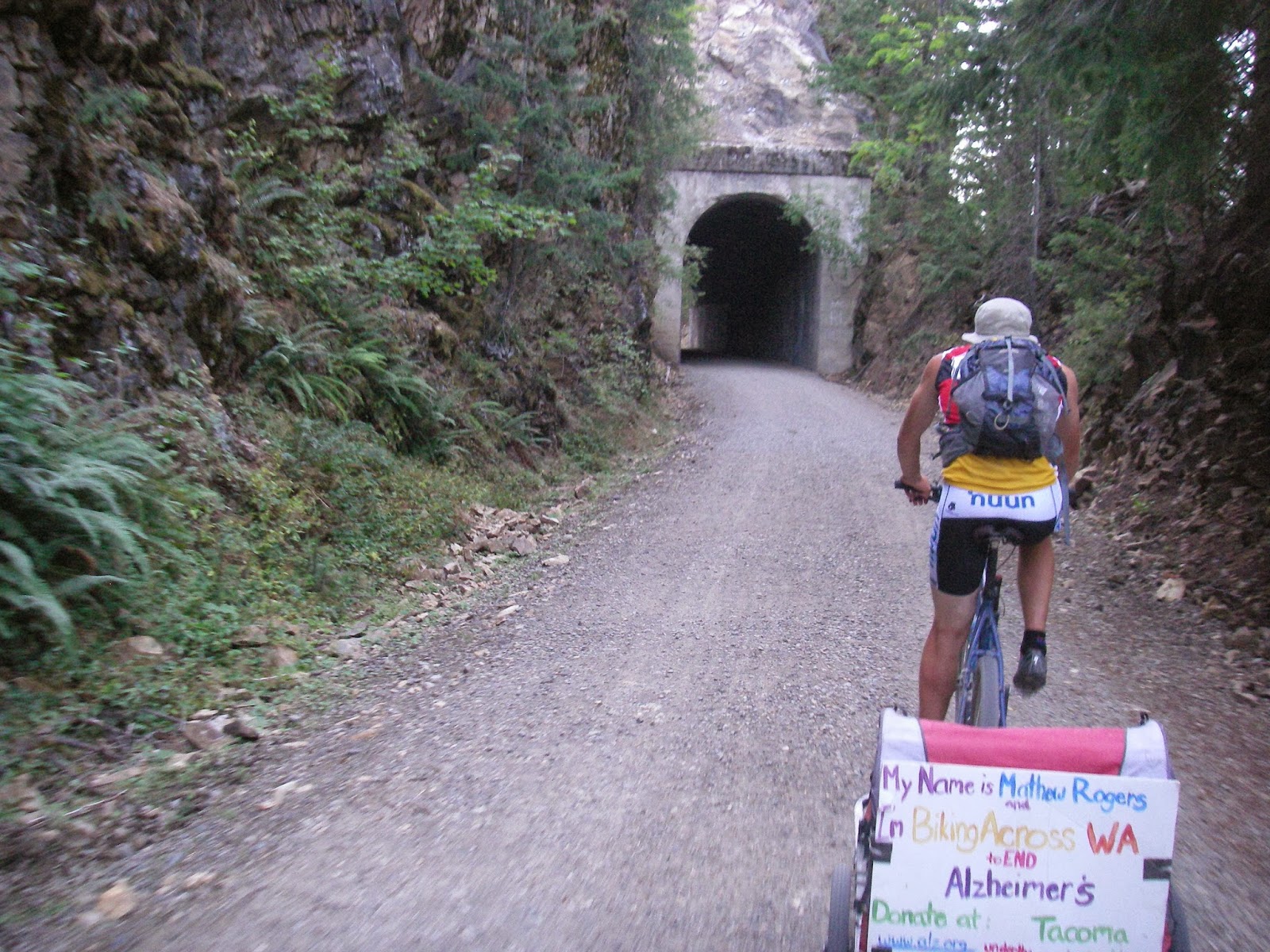
John Wayne Pioneer Trail (the old abandon Chicago, Milwaukee, St. Paul, and Pacific Railroad) to North Bend where it currently ends. The Milwaukee road was used from the early 1900’s until the mid-eighties. From there we would take the Snoqualmie Valley Trail, Falls City Preston Trail, Preston Issaquah Trail, East Lake Sammamish Trail, Sammamish River Trail, Burke Gilman Trail, and Elliott Bay Trail. These are all abandon Railroad trails that would lead us directly to the ferry in Seattle. But because Seattle isn’t technically across the state, Mathew put us on a ferry to Bainbridge where we biked roads to east of Sequim and got on the Olympic Discovery Trail through Port Angeles. If we had time, the plan was to then take the Olympic Adventure Trail further west towards the coast. As it was, we were on roads from Port Angeles to Cape Flattery.

In addition, Mathew had made contact with Trisha Averill of the Alzheimer's Association Western & Central Washington. Trisha scheduled stops at Alzheimer’s facilities along our route. She also worked with Mathew on publicizing and raising awareness for his ride. Along with his ride across the state, Mathew will also be walking in the Tacoma and other walks around the state to raise funds and tell his story. If you enjoy this story, please go here and donate what you can.

The Details:
Maps
BLM 1:100k quads (Rosalia, Ritzville, Connell, Priest Rapids, and Yakima) – Great large scale topo maps with physical details
Gazetteer – road details and names, names of long abandon towns and other man made features. Good maps for rerouting and roads.

Research:
26inchslicks

Gear
Mountain Bikes preferably full suspension with slime tubes and semi-slick 2-2.5 tires
Bike Trailers with slime tubes and preferable large 26inch wheels
Backpacking Camping gear (two man tent, sleeping bags and pads, stove, tarp)
Basic backpacking food with extras purchased along the way
Full bike repair kit with many extra tubes
Water – Bottle, hydration pack, extra gallon carried in trailers
We also carried endurolytes and Hammer Heed
Bike lights (light and motion Stella and seca)
Complete wilderness first aid kit

I purchased the bike trailers used from a moms buy/sell group. Mathew’s red trailer was an instep POS. The woman who sold it to me lied and said it was complete when it was not. It had patch holes that would come undone and it didn’t have the bike connection. It only had 16 inch wheels that I could not replace but the attachment fit Mathew’s bike and I figure he was young and could pull it. I found a burly trailer that was bomber and I was able to replace the wheels with some 26 inch mtn bike fronts I had with 1inch slicks. This trailer rolled and held up real well.

I carried a GPS with me that I turned on every day. Unfortunately it only saved the tracks from the last third of the trip. I suspect that it ran out of memory.

The details that follow are written from the perspective of an old guy, a retired endurance racer who is pretty out of shape. I am pretty slow but I don’t give up. Most of my friends that are still racing and training hard could do this trip super light AR style in half the time easy with no trailers.

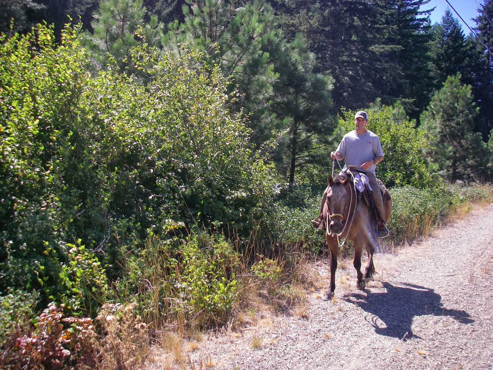
In many of the pictures you will see us without helmets. We always wore helmets when we were or streets with cars or when the speed of our travel warranted it. In most cases we were traveling between 5-8 MPH (jogging speed) on a flat rail bed. Heat related problems were more of a risk than a serious crash. By wearing wet hats, this risk could be safely mitigated. In all other aspects of my life I advocate bike helmets and lead by example.

The Route:My wife Cheryl drove us To Colfax WA the night before the start where we stayed in a motel. Our plan was to make the 30 mile drive to the start at 5:30 the next morning. She would meet us at Cape Flattery 8 days later.

Day One 8/16/13 Idaho Border to Western End of Rock Lake - 54 miles
Day Two Rock Lake to Lind – 51 miles
Day Three Lind to Columbia River – 73 miles
Day Four Columbia River to Roslyn – 67 miles
Day Five Roslyn to North Bend – 53 miles
Day Six North Bend to Suquamish – 75 miles
Day Seven Suquamish to Port Angeles – 53 miles
Day Eight Port Angeles to Cape Flattery – 79 miles

The Odds:
In my mind the odds were not very good.

The GoodMathew is young and doesn’t fully understand what lay ahead.
Mathew will recover well each night with sleep
I am old and suffer well
It is a flat railroad grade
We had a lot of help available to us
We could stop in towns and eat/restock
The wind was cooling

The BadI haven’t been training very much neither has Mathew
Every day I will get worse as I will not recover or sleep as well as Mathew
We were riding on every horrible surface imaginable
The wind was always against us
It was Hot, very HOT
Bikes were not in top condition
Rattlesnakes (we planned on traveling in the morning and evening when they are out the most)

In my mind it was a 50/50 proposition. Anything could and probably would go wrong. From the heat, hydration, nutrition, mechanical problems, snakebites. I knew how to manage myself and by default Mathew. It would mean we would go slow and perhaps not make his goals but not blow up either. My goal was always to be able to get up and ride again the next morning. Unknown to Mathew, I believed the crucible would be the fourth day riding up through the Yakima Firing Range. In my mind if we got through this section, we would get it done.

Monday, September 02, 2013

Looking back through my prior blog entries I realized that I have writtten some stuff that I probably shouldn't have. I could go through and edit a bunch of stuff out but it is done and deleting words will not undo what was written.

If I have insulted, offended, or made anybody mad, I appologize. The last entries in 2010 before this entry were written in a bit of a funk and I will attempt to be more mindful of what I write and keep the blog more light and possibly entertaining.